About Me

My photo
Back Road Whispers is a fanciful name for just liking to travel the back roads of the world, wondering what whispers are lingering in the weathered buildings, rusty farm equipment and closed and boarded up businesses. I stop when I am able and “photograph the past for the future” so my grandchildren and their grandchildren will see what it was like back in the “good old days” of the 20th and early 21st century. Lately I have been exploring the world listening to whispers from palaces, castles, villages, and museums. The whispers need no interpretation.

Sunday, July 27, 2014

Lake Powell, Antelope Canyon, and the Glen Canyon Dam


Lake Powell Resort
Page, Arizona


 Wahweap is translated to "Bitter Water" - bitter maybe, beautiful definitely


A little better peek than we had earlier.  In fact that is the boat we will be taking into Antelope Canyon tomorrow.  Sure looks little....


 No wonder the boat looks so small...the lake is 186 miles long and backs up into more than 96 major side canyons.  The shoreline is 1,960 miles and encompasses 27 million acre-feet with a surface area of 161,390 acres.  It is the second largest, after Lake Mead, man-made lake in the United States.  After the dam was completed it took 17 years for the lake to fill to full level.  This sucker is HUGE!


Views around the resort.  The marina is the largest on Lake Powell and host one of the most luxurious (read $$$'s) houseboats  in America according to HGTV.  The black windowed one, top of the far right side, on the photo below is thought to be it...not sure if it is for rent but other houseboats are if you are so inclined.  Some of them are the permanent homes of the owners.

Recognize the smokestacks in the background?  They are at the Navajo Generating Station.


The fire department was out doing whatever they were doing.  Sure was pretty from my view point.


The came the highlight of the Lake Powell stop...a boat tour of Antelope Canyon.

The formations were absolutely gorgeous, my camera was worn out by the time we returned to the marina.  Enjoy what I saw, there will be very few comments.


The hotel on the left.


 The restaurant on the right.


 Unfortunately the drought has affected the water levels of Lake Powell also, as you can see by the waterline- um, or on the bottom half of the monkey fac.


 There were kids jumping from the the big rock, showing off for the tour boat I think :)

The young lady on the next rock over saw us taking pictures and waved a "wait a minute" type wave and scurried to the edge so she too would be famous.


The fishermen were out trying to catch some of the many fish that reside in the lake:  Walleye, catfish, crappie, small mouth and striped bass, and bluegill.


A view of the dam and bridge from the business side...


And now is when I hush as I promised....


Hanging gardens.


Yup we are going down there


Didn't check to see if anyone was home.


about to turn this corner

Nice spot for a picnic.


I guess all the rocks and formations having names along the way has gone to my head....I saw something in all of them that would lead me to name them.  The following three are my favorite additions to the name game.  You have to use your imagination or be as weird as I am....


 The goldfish or lobster tail (darker rock on top with the flipping tail - even has a dark eye)


Gila Monster!!!!!  See him coming over the top of the rock?


This one is a bit tougher....The Mole Hole
His face is at the 8:00 position with nose and eyes, the top of his mole hole has collapsed behind him forcing him to come out.

Yes, these were named BEFORE the margarita.


Our last afternoon at Lake Powell was a mini-tour of the area.  The first stop was at the Carl Hayden Visitors Center at the Glen Canyon Dam.


 and this is the bridge that the bridgephobic rode across....luckily I was so busy taking pictures and getting first looks at Lake Powell (not to mention feeling safe with Paul behind the wheel) it didn't bother me.


Glen Canyon Dam

The stats which make my eyes glaze over, but in case it is your thing....


Height above bedrock:  710 feet
Height above original river channel:  583 feet
Maximum thickness at foundation:  350 feet
Thickness at crest:  25 feet
Length 665 feet
Width 150 feet
Height 100 feet

COSTS

Dam:   $145,000,000 
Power Plant:  $70,000,000
Recreation Facilities:  28,000,000


Lake Powell was named for Major John Wesley Powell, a civil war veteran who was the first to explore the canyons and the Colorado and Green Rivers..  He kept detailed maps, notes and journals of the explorations and the folks back east waited eagerly for his next chapter.
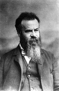
John Wesley Powell 

Courtesy of Wikipedia - camping along the Green River, Wyoming. 

Doesn't everyone wear suits and ties to do their explorations of rugged country?  By the way, I took neither of these photos. :)


Page, Arizona grew from the building of the dam and Glen Canyon Bridge.  The community sprang up for workers and after completion of the bridge and dam, they were reluctant to leave and many remained to form the nucleus of a new community.

We took a tour of Page, including one of the favorite stops on the tour...


On one of the previous tours one of the passengers asked Bruce if there was somewhere they could buy some "digestive" medicine.  (They probably had eaten the whole regular Indian Fry Bread Taco).  Since it was right there on their route they pulled into the Walmart lot.  The ones wanting the medicine got off the bus and everyone else did too!  They all came back carrying bags of beer, wine, food, and other necessities.  So it became a regular stop.  It was perfect since it was about halfway through the tour which is when you start thinking "why didn't I pack some XXXX".  Scott and I bought sandwiches for $2.00 instead of the usual $20.00 and I got a couple of zippered tote bags that I thought I might need since someone who calls me "Mom" was hitting every gift shop in sight and not buying bookmarks.

The town was sorta cool in its layout.  All the churches were along one circle (10:00 Sunday morning has got to be the granddaddy of all traffic jams), all the emergency services were clumped together, the boating shops and services, etc.  Whatever your need was it could easily be found by going to one section of town.

Along the way we passed, but didn't stop at the John Wesley Powell Museum.  Outside was a replica of the boat he and his crew used to do their explorations.

The Emma Dean

Emma Dean was John W. Powell's wife

He has been honored by the following, also found on Wikipedia:

  • In recognition of his national service, Powell was buried in Arlington National Cemetery.
  • Lake Powell, a man-made reservoir on the Colorado River, was named for Powell.
  • Powell Plateau, near Steamboat Mountain on the North Rim of the Grand Canyon was also named in his honor.
  • Powell, Wyoming Major Powell never explored the Powell flats given his name.[15]
  • In Powell's honor, the USGS National Center in Reston, Virginia, was dedicated as the John Wesley Powell Federal Building in 1974. In addition, the highest award presented by the USGS to persons outside the federal government is named the John Wesley Powell Award.
  • The residential building of the Criminal Justice Services Department of Mesa County in Grand Junction, Colorado, is named after John Wesley Powell.[16]
  • John Wesley Powell Middle School is located in Littleton, Colorado.[17]
  • Powell Jr High School is located in Mesa, Arizona.
  • He was portrayed by John Beal in the 1960 film Ten Who Dared.

 We were worn out from out exciting trip to Walmart, so ate our $2.00 sandwiches and cupcakes and headed to bed.  One of our tour mates stayed up to watch the moon rise and said it was beautiful.  Hopefully I can talk her out of some pictures.

Up the next morning to see the sunrise at least, and it was beautiful.


And off we went for more adventures in Kanab, Bryce Canyon, and our final stop at Zion National Park.


Friday, July 25, 2014

The Navajo Nation

After I finally closed my mouth (no comments people), and quit gaping at the beauty of the Grand Canyon, it was time to head toward The Navajo Nation and Monument Valley.

Well maybe one last peek....


We went back up the East Rim road but this time I was on the picturesque side and didn't have to shoot through snoozing passengers.

On the way to Monument Valley we saw many changes in the topography.  There are some fascinating formations designed from wind and rain.


Lots of different homes, single wide mobile homes, Hoguns (hoogans in Navajo), basic wood frame, but no wig wams or teepees -  those were Plains dwellings.


One thing for sure, the front door will always point east - even the outhouse doors point east.  The reason they point east is to welcome the sun as it rises. 


The sign on the mobile home says "Bed and Breakfast" - yup, you can spend the night in an authentic Hogun.


Some were in better shape than others


One of the octaganol Hoguns - a favorite design


Shopping Mall :)


We even took a side trip to the moon.  


Painted Desert, home of the Navajo Nation

I try very hard to remain apolitical but this was heart wrenching I had to share. You can Google it and draw your own conclusions.  I haven't researched it enough to draw mine, but do know the methods used were barbaric in my estimation.

I borrowed this from http://navajopeople.org/blog/mount-hesperus-navajo-sacred-mountain/

That website is an excellent source of information about the culture, beliefs, and traditions of the Navajo.

 The Four Navajo Sacred Mountains

Mount Blanca (Tsisnaasjini’ – Dawn or White Shell Mountain – East
Mount Taylor (Tsoodzil – Blue Bead or Turquoise Mountain) – South
San Francisco Peaks (Doko’oosliid – Abalone Shell Mountain) – West
Mount Hesperus DibĂ© Nitsaa (Big Mountain Sheep) – Obsidian Mountain – North

It was important to the Navajo and their peace of mind and spirit that they live within the confines of these four sacred mountains.  This they did in the Painted Desert until the United States in its infinite wisdom decided it would be a good idea to relocation them to Bosque Redondo in Eastern New Mexico.  

As with any conflict there are two sides, but there is also humanity and I see little of that in the method of relocation.  Men, women, children, and the elderly and infirm were forced at gun point to walk the 300 miles in 18 days beginning in the spring of 1863.  The estimate is that 8-9,000 individuals were made to endure this walk and an estimated 200 perished along the way.  There were more than one group converging on Ft. Sumner, in the Bosque Redonda (river bottom forest containing Cottonwood trees).  

The 40 square miles was not adequate for that many individuals to live together and thrive.  Crops were infested, rival tribes continued their disputes, inadequate management of supplies by the military and sickness as well as the trials of nature made life unbearable.  Raids on non-Indian settlers were carried out in order to feed their families, raids on other tribes happened for the same reason.  


In 1868 a treaty was signed giving the Navajo back their land with various stipulations (schooling for the children, seeds and agricultural instruments, protection rights).  One signer of the treat was General W. T. Sherman of Civil War fame.  On June 18, 1968 the Navajo began their long walk home.  The treaty granted them 3.5 million acres, within their four sacred mountains, which they have increased over the years to 16 million acres.  It is said that the Navajo became a more cohesive group after the Long Walk.

OK, on to happy happy land.


 But first we have to get there and have lunch at Goulding's Trading Post.  A combination of motel, restaurant, museum and trading post.  I


n 1921 Harry and his wife, Leone (Mike), bought 640 acres of land next to Monument Valley.  They set up a trading post out of a tent and in 1928 erected a stone trading post with an apartment on the second floor (now the museum).  The Depression hit the western states too and things were looking bleak for both the Gouldings and the Navajo.  Harry Goulding took several photographs of the area and headed to Hollywood touting the land as the perfect locale for movie westerns.  One director was intrigued and began filming with a young new actor - that director was John Ford, the young actor was John Wayne, and the movie was the award winning Stagecoach.  Both Ford and Wayne returned many times to film in the Monument Valley. The locals were hired in many areas including extras in the movies.  The goodwill of the Gouldings did not stop with bringing Hollywood to the valley, they to this day still support various causes within the Nation.


 We had lunch at Goulding's and luckily Bruce had warned us they were very generous with their portions.  He specifically mentioned the Indian Fry Bread Taco and to order the mini.  I trusted him thank heavens.  I wish I had taken a photo of the what I sent back, all I could manage was eating around the edges.  It was excellent, by the way.


 This is a normal sized dinner plate from a cafe/diner, not salad plate size.  Looks like a mouse got into mine. :)

When we left Goulding's the crossing guards were on duty at the corner.  Coming in we had to wait for some sheep to cross.  It is their land, not ours, after all.


Off we went into Monument Valley on a jeep tour.  The jeep held twenty passengers and had never see a pair of shock absorbers in its long life.  It was well worth the new organs I had to buy to replace my original spleen, liver and kidneys. 


Merrick Butte

Named after one of the two prospectors who discovered silver in the valley.  Unfortunately, the Ute discovered the prospectors, stole the silver and killed Mr. Merrick and Mr. Mitchell.


The Mittens, left and right or east and west.  Although they look like hands they signify that spiritual beings are watching over the land and people.


We had a couple of stops, I think they were hoping our organs would return to the correct position.
There were usually jewelry for sale, drinks (hot coffee at one?????), and great views.  The booth above was not open but proudly flying the flag.


This guy was at Ford's Point and selling photographs with the horse, either astride or standing beside him.  After a bit the man brought the horse back and let him get a drink, then took him over to a shade (a rough structure made of branches providing shade but loosely built so air could circulate).


The Three Sisters....a Catholic nun facing her two students.


I did what I could with the stops and the jeep from Hell (wouldn't have missed the ride for anything) but if you want to see some spectacular shots that are identified much better than I could do go to:

http://www.digital-images.net/Gallery/Scenic/Southwest/IndianLands/MonumentVly/Scenics/scenics.html

POWER!

One interesting part of the trip into the Painted Desert and The Navajo Nation was that the Hopi reside on top of Black Mesa in the middle of the nation.  The Hopi and the Navajo are not what you would call kissing cousins so it was surprising the Hopi were there.

At any rate the Hopi have Black Mesa mine on top of that mesa and they harvest coal.  I believe Bruce said they have a 200 year reserve of coal, so they will be in business for awhile.  Anyway, they mine it and then it goes down this conveyor belt from the top of the mesa to the silo.


The silo sits on a train track and holds the coal until it is shipped via railroad car to the Navajo Generating Station close to Page, Arizona on the Utah border.  The rail cars are fully automatic and run 24 hours a day.


The NGS is a 2250 megawatt coal fired power plant that provides electricity to customers in Arizona, Utah and Canada.  After seeing the vast desert vistas with few man made structures it was a bit jarring to see the big thingies that transport the electricity.  God ran out of left brains when he made me, but I did find it interesting from start to finish.  The lack of the left brain makes it impossible to tell you why the emissions from the power plant are so little, but it is by design.


A peek at Lake Powell and a promise of things to come.